Property Record
5261 Buford Hwy, Norcross, GA 30071
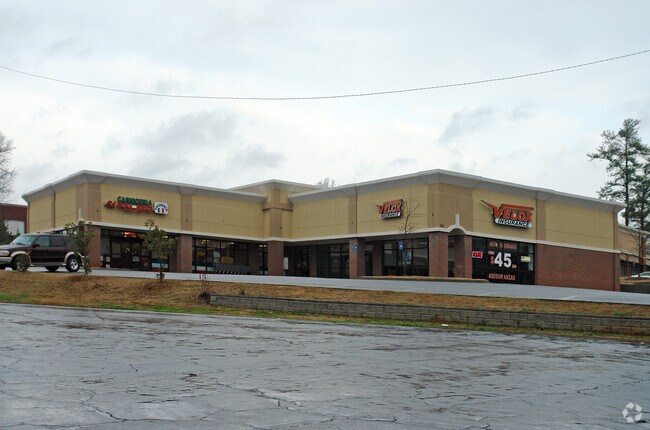

Property Detail
5261 Buford Hwy
6-256-294
PT L5 BUFORD HWY
Stripcommercialcenter
Gwinnett
C2
Georgia
B and X Area of moderate flood hazard, usually the area between the limits of the 100-year and 500-year floods.
5
2025
0.82 AC
2025
Norcross/Peachtree
050311
Atlanta
8,976 SF
Atlanta-Sandy Springs-Roswell, GA
NEARBY LISTINGS FOR SALE OR LEASE
DEMOGRAPHICS near 5261 Buford Hwy
1 mile
3 mile
5 mile
2025 Total Population
9,598
81,704
260,578
2030 Population
10,034
84,984
269,623
Pop Growth 2025-2030
+ 4.54%
+ 4.01%
+ 3.47%
Average Age
37
37
37
2025 Total Households
3,265
29,385
94,690
HH Growth 2025-2030
+ 4.56%
+ 4.02%
+ 3.49%
Median Household Inc
$81,161
$72,549
$67,989
Avg Household Size
2.90
2.70
2.70
2025 Avg HH Vehicles
2.00
2.00
2.00
Median Home Value
$399,149
$424,627
$395,211
Median Year Built
1991
1990
1988
Nearby Places
Map Layers
Map Styles
 Street
 Aerial
Transit
 Traffic
 Biking
Places
Listings with unknown addresses are not visible on the map
- Restaurants
- Banks
- Shops
- Fitness
- Groceries
PUBLIC TRANSPORTATION
AIRPORT
Hartsfield - Jackson Atlanta International
Drive
Walk
Distance
Hartsfield - Jackson Atlanta International
42 min
30.2 mi
SALE & LEASE HISTORY
LISTING DATE
SALE/LEASE

Oct 27, 2020
For Lease
Oct 27, 2020
For Sale
Jun 18, 2020
For Sale
Jun 05, 2019
For Sale
Jul 30, 2021
For Sale
Jan 27, 2021
For Sale
Dec 29, 2020
For Lease
Dec 29, 2020
For Sale
Dec 08, 2019
For Lease
Aug 05, 2021
For Sale
Nearby Properties
Address
Land Use
TOTAL SIZE
Lot Size
Zoning
Address
Land Use
TOTAL SIZE
Lot Size
Zoning
599,105 SF
9.13 AC
M1
Address
Land Use
TOTAL SIZE
Lot Size
Zoning
709,399 SF
59.34 AC
RM13
Address
Land Use
TOTAL SIZE
Lot Size
Zoning
761,929 SF
65.19 AC
RM13
Address
Land Use
TOTAL SIZE
Lot Size
Zoning
346,219 SF
21.95 AC
PUD
Address
Land Use
TOTAL SIZE
Lot Size
Zoning
425,597 SF
49.61 AC
RM13
Address
Land Use
TOTAL SIZE
Lot Size
Zoning
524,000 SF
44.93 AC
RM
Address
Land Use
TOTAL SIZE
Lot Size
Zoning
545,074 SF
53.40 AC
RM8
Address
Land Use
TOTAL SIZE
Lot Size
Zoning
439,676 SF
42.88 AC
RM13
Address
Land Use
TOTAL SIZE
Lot Size
Zoning
525,526 SF
80.61 AC
RA200
Address
Land Use
TOTAL SIZE
Lot Size
Zoning
286,481 SF
20.06 AC
M1
Address
Land Use
TOTAL SIZE
Lot Size
Zoning
231,192 SF
12.88 AC
RM13
Address
Land Use
TOTAL SIZE
Lot Size
Zoning
303,866 SF
20.13 AC
RM
Address
Land Use
TOTAL SIZE
Lot Size
Zoning
424,948 SF
39.03 AC
RM13
Address
Land Use
TOTAL SIZE
Lot Size
Zoning
426,839 SF
37.47 AC
MUD
Address
Land Use
TOTAL SIZE
Lot Size
Zoning
250,886 SF
22.93 AC
RM13
Address
Land Use
TOTAL SIZE
Lot Size
Zoning
483,279 SF
8.27 AC
BH
Address
Land Use
TOTAL SIZE
Lot Size
Zoning
475,389 SF
5.37 AC
NX
Address
Land Use
TOTAL SIZE
Lot Size
Zoning
220,150 SF
21.08 AC
RM13
Address
Land Use
TOTAL SIZE
Lot Size
Zoning
561,975 SF
41.78 AC
RM13
Address
Land Use
TOTAL SIZE
Lot Size
Zoning
420,576 SF
27.06 AC
M2
Address
Land Use
TOTAL SIZE
Lot Size
Zoning
340,962 SF
34.50 AC
PRD
Address
Land Use
TOTAL SIZE
Lot Size
Zoning
454,220 SF
30 AC
M1
Address
Land Use
TOTAL SIZE
Lot Size
Zoning
220,915 SF
2.38 AC
HX
Address
Land Use
TOTAL SIZE
Lot Size
Zoning
720,051 SF
99.46 AC
MUR
Address
Land Use
TOTAL SIZE
Lot Size
Zoning
351,072 SF
20.03 AC
RM24
Address
Land Use
TOTAL SIZE
Lot Size
Zoning
225,314 SF
68.32 AC
OI
Address
Land Use
TOTAL SIZE
Lot Size
Zoning
781,705 SF
60.29 AC
M1
Address
Land Use
TOTAL SIZE
Lot Size
Zoning
399,780 SF
27.24 AC
RM
Address
Land Use
TOTAL SIZE
Lot Size
Zoning
428,933 SF
50.01 AC
PRD
Address
Land Use
TOTAL SIZE
Lot Size
Zoning
228,548 SF
16.50 AC
RM10
The World's #1 Commercial Real Estate Marketplace
Connect with us
© 2026 CoStar Group
The information above has been obtained from sources believed reliable. While we do not doubt its accuracy we have not verified it and make no guarantee, warranty or representation about it. It is your responsibility to independently confirm its accuracy and completeness. Any projections, opinions, assumptions, or estimates used are for example only and do not represent the current or future performance of the property. The value of this transaction to you depends on tax and other factors which should be evaluated by your tax, financial, and legal advisors. You and your advisors should conduct a careful, independent investigation of the property to determine to your satisfaction the suitability of the property for your needs.